skip to Main Content

I’m using flutter_map to display map on my flutter app.

here is the code

FlutterMap(
            mapController: mapController,
            options: MapOptions(
              interactiveFlags:
                  InteractiveFlag.pinchZoom | InteractiveFlag.drag,
              center: LatLng(9.964706, 76.289714),
              zoom: 13.0,
              rotation: 0,
            ),
            children: [
              TileLayer(
                urlTemplate:
                    'https://maps.wikimedia.org/osm-intl/{z}/{x}/{y}.png',
                subdomains: const ['a', 'b', 'c'],
              ),
              MarkerLayer(
                  markers: List.generate(
                userList.length,
                (index) {
                  final user = userList[index];
                  return Marker(
                    width: 200,
                    height: 200,
                    point: LatLng(user.coords[0], user.coords[1]),
                    builder: (ctx) {
                      return GestureDetector(
                        onTap: () => showuserDetailSheet(context, user),
                        child: UserPointer(
                          color: user.color,
                          icon: user.gender == Gender.male
                              ? Icons.male
                              : Icons.female,
                          name: user.username,
                          age: user.age,
                        ),
                      );
                    },
                  );
                },
              ))
            ],
          ),

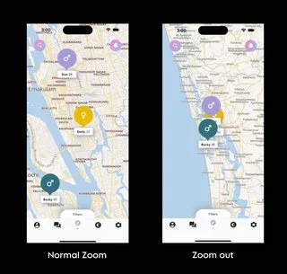
here is the screenshots for better understanding

enter image description here

i want to reduce the size when the user zoom out the map or increase the size when user zoom in. how do i do that in flutter map

2

Answers


  1. You can achieve this by listening to the onPositionChanged event of the MapOptions and then update the marker size based on the zoom level.

    import 'package:flutter_map/flutter_map.dart';
    import 'package:latlong2/latlong.dart';
    
    class YourMapWidgetState extends State<YourMapWidget> {
      MapController mapController;
      double _markerSize;
    
      @override
      void initState() {
        super.initState();
        mapController = MapController();
        _markerSize = 200.0; // Default marker size
      }
    
      void _updateMarkerSize(double zoom) {
        // Update the marker size based on zoom
        setState(() {
          _markerSize = 200.0 * (zoom / 13.0);
        });
      }
    
      @override
      Widget build(BuildContext context) {
        return FlutterMap(
          mapController: mapController,
          options: MapOptions(
            interactiveFlags: InteractiveFlag.pinchZoom | InteractiveFlag.drag,
            center: LatLng(9.964706, 76.289714),
            zoom: 13.0,
            rotation: 0,
            onPositionChanged: (position, hasGesture) {
              if (hasGesture) {
                _updateMarkerSize(position.zoom);
              }
            },
          ),
          children: [
            TileLayer(
              urlTemplate: 'https://maps.wikimedia.org/osm-intl/{z}/{x}/{y}.png',
              subdomains: const ['a', 'b', 'c'],
            ),
            MarkerLayer(
              markers: List.generate(
                userList.length,
                (index) {
                  final user = userList[index];
                  return Marker(
                    width: _markerSize,
                    height: _markerSize,
                    point: LatLng(user.coords[0], user.coords[1]),
                    builder: (ctx) {
                      return GestureDetector(
                        onTap: () => showuserDetailSheet(context, user),
                        child: UserPointer(
                          color: user.color,
                          icon: user.gender == Gender.male
                              ? Icons.male
                              : Icons.female,
                          name: user.username,
                          age: user.age,
                        ),
                      );
                    },
                  );
                },
              ),
            ),
          ],
        );
      }
    }
    
    Login or Signup to reply.
  2.     you can set the size of a **location marker** based on the zoom level of the map by using the **onPositionChanged** callback of the GoogleMap widget.
            
            1. example calculation of the marker size based on the zoom level of the map.
            double calculateMarkerSize(double zoom) {
              if (zoom <= 10) {
                return 20.0;
              } else if (zoom <= 15) {
                return 30.0;
              } else {
                return 40.0;
              }
            }
            
            2. In the _onCameraMove callback start implementing the calculation function for the size of the marker based on the zoom position.
            
            void _onCameraMove(CameraPosition position) {
              setState(() {
                _markerSize = calculateMarkerSize(position.zoom); // function to calculate the marker size based on the zoom level
              });
            }
            
            3. Implement those callbacks in the google map widget 
            
            GoogleMap(
              onMapCreated: _onMapCreated,
              onCameraMove: _onCameraMove,
              markers: _markers,
            ),
        
        4. then use the calculated result of the marker size in the marker.
    
    
    Set<Marker> _markers = Set<Marker>();


    @override
      void initState() {
        super.initState();
        _markers.add(
         Marker(
      markerId: MarkerId('marker'),
      position: _currentPosition,
      icon: BitmapDescriptor.fromAssetImage(
        ImageConfiguration(size: Size(_markerSize, _markerSize)),
        'assets/marker.png',
      ),
    ),
        );
      }
    
    Login or Signup to reply.
Please signup or login to give your own answer.
Back To Top
Search